
Earth monitoring
NASA Turns Over Control of Landsat 9 to USGS
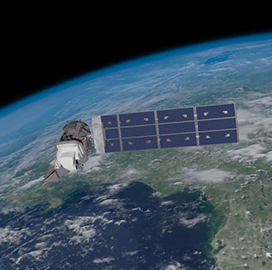
The National Aeronautics and Space Administration announced that it has transferred ownership and operational control of the Landsat 9 satellite to the U.S. Geological Survey. Landsat 9 is one in a series of remote-sensing satellites that provide global coverage of landscape changes on Earth, NASA said Thursday.

In a statement, NASA said that the satellite’s turnover was made official in ceremonies held at a USGS facility in Sioux Falls, South Dakota. During the event, NASA Administrator Bill Nelson said Landsat 9 represents the latest joint effort between the space agency and USGS, in a partnership that has spanned more than half a century.
Nelson said that for more than 50 years, Landsat satellites have helped researchers learn more about how Earth systems work and how human activities affect those systems. Insights gained from the family of satellites have aided policy-makers in making better decisions for the future, he added.
For her part, Assistant Secretary for Water and Science Tanya Trujillo said the USGS’s long partnership with NASA has proven good for science and for the American people. She explained that Landsat’s 50-year record gives scientists a consistent baseline that can be used to track climate change and enables them to see changes to the land over time.
Landsat 9 was launched from Vandenberg Space Force Base in California on Sept. 27, 2021. It joined Landsat 8, which has been orbiting Earth since 2013. The first Landsat satellite, Landsat 1, was launched on July 23, 1972, according to the USGS.
Category: Space